Yesterday was my birthday. And it was rainy. So I took the day after off work and headed to my happy place for a hike. I did a hike very much like this three years ago. In fact, this is the hike I intended to do then. But I misread the map while I was planning my route and missed the Basin Cascade Trail.
I started off by parking in the southbound lot for The Basin (around 7:45 AM on a Friday, so there were hardly any cars there yet). The only other hikers I saw between the parking lot and the Cascade Brook Trail (AT) junction nearly a mile and a half later were a woman and her (absolutely adorable) small dog.
Shortly after heading southbound on the AT at the Cascade Brook Trail, I encountered several northbound thru-hikers and a couple of section hikers. Once I reached Lonesome Lake, the trail got much more populated with families and day-hikers heading up to the lake, the Kinsmans, or Cannon Mountain from the Lafayette Place campground/trailhead parking.
At the lower end of the Lonesome Lake Trail, I walked through the campground and headed south on the Franconia Notch Recreational Trail, which is a shared multi-use trail. I was passed by several cyclists in both directions, as well as a couple scooters (that the rider stands on) heading north.
Once I arrived back at The Basin parking lot, it was pretty full and there were numerous walkers, tourists, hikers, and runners milling about on the trails. I made my way out of the park and headed south for my customary post-hike iced mocha latte from the Campton Dunk’s off exit 28 before returning home.
It was time for my annual vacation with the girls, which meant it was also time for my annual hike with Mela. Since our vacation this year was in our native Pennsylvania, Mela and I kept our hike close to my former home. (I am kicking myself for not hiking more while I lived in PA and so close to these trails… but I was so much more of a workaholic then.)
Anyhoo… we started at Port Clinton, parking at the (small!) AT trailhead parking lot along Route 61 South. We took the blue-blazed connector trail from the parking lot down to the Appalachian Trail, right by the Schuylkill River. (Locally, “Schuylkill” is most commonly pronounced “skook-ill,” in case you were wondering. Technically, “skool-kill” is probably closer to correct, but we get lazy with the “L”.)
After a brief hike along the river among the invasive weeds intermingled with tiger lilies and hosta, we crossed under Route 61. Here, there’s a tremendous amount of graffiti, including an awful lot of strange sharpie-scrawled rantings. Since we started early, just before 6:00 AM, there was someone sleeping under the overpass. Mela thought maybe a hiker, I thought maybe homeless. Either could be true. Perhaps the author of the sharpie-scrawled rantings, but most likely not – those began at least a couple years ago and he may no longer be camped out there. We quickly and quietly made our way through to the other side and began climbing up to the road crossing at Blue Mountain Road/Port Clinton Avenue.
We crossed Blue Mountain Road, then ascended steeply to the ridge, following a switchback near the top. Once we reached the ridge, we found a peek-a-boo view of Hamburg to the southeast. Over the next 3.5 miles, we walked the ridge, then descended into Windsor Furnace.
Now I was in familiar territory, having hiked from Windsor Furnace to the Pinnacle (and looping back) last fall. Shortly after departing Windsor Furnace, we took a side trip to the privy by the shelter – the sign said the privy was still closed, but it wasn’t blocked off and clearly looked like it was being used. However, we chose not to use it! It was also the most unusual privy I’ve ever seen, since the contents all remained above ground, contained within a wood-and-chicken-wire structure. (Take a look if you dare.) Surprisingly, the area was not as stinky as I thought it would be.
We returned to the trail and continued climbing up to the Pulpit Rock overlook. I was glad to see that despite the rain in the forecast, we had a view! (Somewhere along the way we did get rained on briefly, but writing this a full week afterward I can’t remember if that was before Pulpit Rock or between Pulpit Rock and the Pinnacle.) We sat on a big rock in the shade and took a snack break, then continued on to the Pinnacle.
Once we reached the Pinnacle, I walked out as far as I could on the ledge and began looking for our friend Tina’s house among the farmland below. I was unsuccessful, and figured her house was farther to the left and blocked by trees. (I later learned that her house IS visible from the Pinnacle, but it’s much farther away than where I was looking.) After several minutes on the Pinnacle, a sudden downpour started. We quickly scurried off of the rocks, put on raincoats, and headed back into the woods to resume our hike.
I was surprised how few people (less than 6) were at the Pinnacle, considering it was late morning on Saturday of a holiday weekend and it’s probably the most popular hiking destination in the area. The rainy forecast probably helped.
It rained for just about all of the last 5.5 miles of our hike. Along the way, we chatted briefly with an older gentleman who was thru-hiking, but only expecting to get to Vermont this year (this was not his first attempt, and it didn’t sound like it would be his last, either).
When we had about 4 miles to go, I texted Tina (took some time to go through due to lack of signal) to let her know our expected arrival time… and to bring towels! I texted her again once we reached Hawk Mountain Road. Thankfully, it had stopped raining. While we waited for Tina to arrive, we said hello to some thru-hikers on their way back to trail from the Eckville Shelter. We also had some time to chat with a thru-hiker from New Hope, PA who was hiking for the day with a local friend and his son. (Of course, I didn’t think to ask any of the thru-hikers for their trail names…)
Soon, Tina arrived (with towels!) and drove us back to her house to dry off, rest, and visit for a bit. As we were drying our gear and ourselves off on her sunny deck, it started raining again and we hurried inside. We enjoyed looking up at the ridge we had just hiked from her yard (before it rained) and from her living room window (after it started raining).
After our visit, Tina drove us back to the parking lot where we left my Mom’s car, and we returned to Blue Rocks Campground where we were staying for the weekend.
About “Rocksylvania”
Thru-hikers over the years have nicknamed Pennsylvania as “Rocksylvania” due to the plentiful rocks along the trail. And generally, the stretch of trail between Port Clinton and Hawk Mountain Road is considered to have some of the worst rocks, from what I’ve heard in various thru-hiker videos on YouTube.
However, I feel I have a bit of a unique viewpoint. I grew up in Pennsylvania and spent nearly the first 40 years of my life living here. Though I was not as avid a hiker then as I am now, I did hike – at summer camp when I was a kid, and annually for a wedding anniversary hike for a bunch of years. Most of the hiking I have done in PA was at Hawk Mountain, which has similar terrain to this section of the Appalachian Trail.
Now, I live in New Hampshire. I’ve hiked all of the NH 48 4000-footers, including Mt. Washington, Mt. Jackson, Mt. Osceola/East Osceola, and Mt. Whiteface twice. I’ve also hiked lots of smaller mountains, and regularly hike in the Belknap Range (though I haven’t been posting about it here lately). I can say without a doubt that NH is way rockier than PA. And considering the significantly higher elevation gain in the White Mountains, I find hiking in PA with the lower elevations to be far easier, regardless of the rocks. Consider my moving pace. For this hike, which was also higher mileage than I normally hike, my moving pace was 25 minutes per mile. My typical pace for a hike of a similar length in the White Mountains is more like 40-45 minutes per mile and sometimes even slower than that.
Those are my 2 cents on the rocks of Pennsylvania!
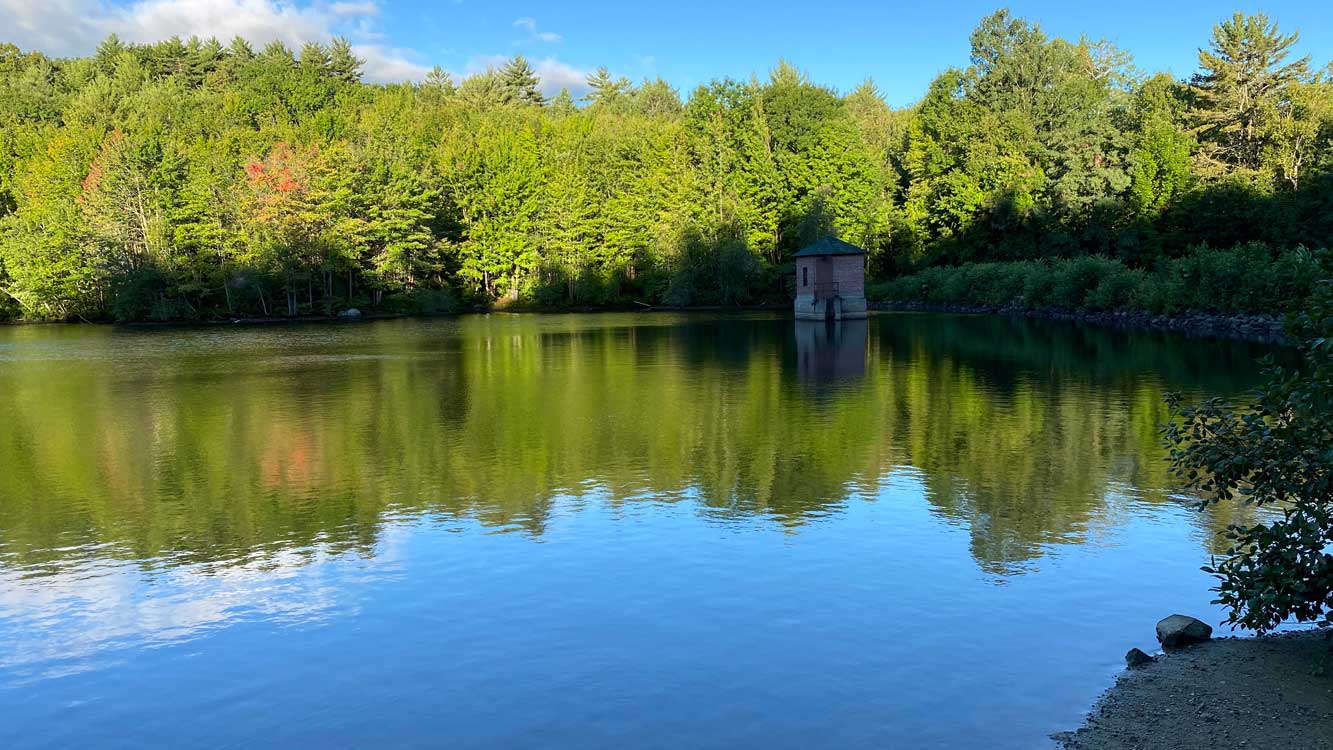
After living here for nearly 12 years, I finally visited the state park that’s only a few miles from my house. I rode my bike there, taking the longer (but safer) way – on the WOW Trail into downtown Laconia. I don’t have the right kind of tires for mountain biking, so I locked up my bike at the entrance gate and went for a short hike down to Lake Winnisquam.
I didn’t do as much hiking this year because, well, that’s 2020 for you. I guess I was trying to avoid all the non-hikers that were (and still are) crowding the trails. For that reason, I’m no longer revealing the locations of my hikes. There might be some clues in the photos, but you’ll have to put in the work and do some research if you want to try to figure out where these trails are. (And considering the lack of research some people do before they go on a hike, I suspect if you’re researching a hike you won’t be abusing the trails.)
Since my last post, I continued trail running after work a few times a week throughout September, and managed to fit in some weekend hikes in October. Then busy season arrived at work and my life became work, eat, sleep for about a month and a half. I finally started hiking again on December 20th with some snowshoeing after we got 3 feet of snow dumped on us!
I’ve been sticking with lower elevation mountains, community forests, and conservation areas as I normally do in the winter months. It’s all about getting outdoors and moving around while avoiding crowded trails and going early so it’s not as peopley.
I think I’ve stated in the past that I’m no trail runner. I still don’t consider myself a trail runner… but I have been trail running for the past week.
No, I’m not breaking any speed records. In fact, my trail running pace is pretty much in line with my walking-around-town-on-paved-sidewalks pace. But, that’s faster than my hiking pace, even my hiking pace on easy trails.
The trails I’ve been running on are low elevation town forest trails that aren’t super rocky or rooty. Weeks Woods is a short detour on my drive home from work, so for now it’s easy enough to change before leaving the office and squeeze in a quick run (30-35 minutes over about 2 miles). That won’t last much longer as the days get shorter and shorter.
One park I keep forgetting about (mostly because I don’t typically go there in summer) is Waukewan Highlands Community Park. I’ve done quite a bit of hiking and snowshoeing there over the past several years. I suddenly remembered it yesterday and thought the low elevation red and white trails, as well as a section of the yellow trail, would be good for trail running. The drawback to running these trails, though, is that it’s awfully short. My run ended up being only 1.35 miles. I should have really done 2 laps, but it was a good first outing.
I arrived just before 7:00 AM. There were two cars in the parking lot, and from one of them emerged a young woman and her dog, headed to the trails for a morning walk. They took the white trail.
I chose to start with the red trail, running mostly downhill toward the reservoir (also known as Jan Pond or Hart’s Pond). Arriving at the pond, I passed by the woman and her dog on their way up the red trail to the parking lot.
After stopping briefly at the pond for a quick stretch (and noticing how incredibly low the water level was, even after the rain we got yesterday), I continued on to the yellow trail. This stretch of trail starts off along the stream that flows out of the reservoir; however, due to the drought conditions the stream was completely dry.
I had originally intended to follow the yellow trail and keep going straight where the trail takes a turn to the right, up through the woods and into a large meadow along Parade Road. Going straight, the trail exits the park, following along the stream, and emerges onto Reservoir Road in Meredith. However, as I approached the turn, there was a man leisurely walking his dog in the same direction I was headed. It felt kind of rude to pass them while they were enjoying a nice stroll on a secluded trail, so I turned around when I reached the right turn in the trail and headed back to the pond.
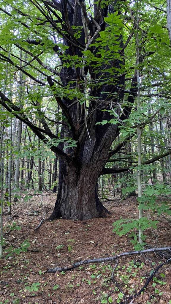
This tree on the yellow trail is huge. The trunk is about 4 feet across!
Returning to the pond, I took a left and continued on the gated access road for a short bit, then turned right onto the white trail and made my way back to the parking lot. This section alternates between flat and gentle uphill grades, so I alternated between running and walking.
When I got back to my car, I made sure to stretch my calves well, and also did a couple of quick quad stretches before getting in the car. I’ve learned I really need to do this so my legs don’t get stiff from sitting in the car, even when it’s a short drive to get back home.
I met up with some former coworkers for an outdoor, socially-distanced gathering. There’s a local bookstore, Bayswater Books, near our meeting site, so I gave myself a little extra time to browse for some hiking books.
I found a copy of Bill Bryson’s A Walk in the Woods among the used books for sale on the porch outside the bookstore. Inside the store, I held back a little and added only three more books to my purchases. These were all hiking related, of course. And all three by local authors:
Paths Less Traveled: Tramping on Trails (And Sometimes Not) to Find New Hampshire’s Special Places by Gordon DuBois
The White Mountain: Rediscovering Mount Washington’s Hidden Culture by Dan Szczesny
Wandering Through the White Mountains: A Hiker’s Perspective by Steven D. Smith
Hiking books purchased at Bayswater Books
I actually met Gordon DuBois (and his dog, Reuben) while hiking the Piper-Round Pond Link trail shortly after it had been rerouted a several years ago. Gordon was trimming back brush on the new trail, while Reuben served as the welcoming committee for other hikers (me) passing by.
Though I’ve never met Dan Szczesny, he is a friend of my hiking friends Neil and Karen. The White Mountain has been on my to-read list ever since it was published a couple years ago.
Steve Smith is the owner of the Mountain Wanderer bookstore in Lincoln, NH. He is probably best known as the co-author of The 4000-Footers of the White Mountains, which is a must-have guidebook for anyone hiking the high peaks of New Hampshire. He is also the editor of AMC’s White Mountain Guide.
Sunday, August 23, 2020: Lockes Hill
My original plan was to do a sunrise hike up Lockes Hill, but I went to bed too late. Plus, the Glade overlook and summit are mostly north-facing with views over Lake Winnipesaukee. Not a good viewing angle for sunrise anyway. So I figured I would just try to get to the trailhead by 6:30 AM.
When my alarm went off, I looked out the bedroom window and saw nothing but fog. I reset my alarm for a later time. It was still foggy when I got out of bed, but I figured maybe the overlooks would be clear and I’d have views of the undercast or fog over Lake Winnipesaukee.
I started my hike just a little later than planned, arriving at the trailhead about 6:45 AM. There was no fog at the trailhead, but I could see some clouds resting low over the lake, farther away from shore.
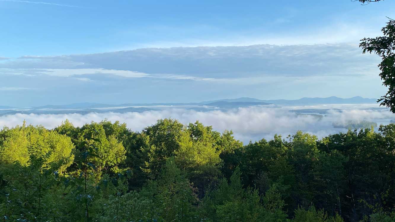
Arriving at the Glade overlook, about one-third of the way through the entire loop, I took a brief break to take some pictures of the fog over the lake. Continuing on to the summit, I passed by a man trail running down as I was climbing up. The view isn’t as good at the summit due to trees growing in, but I managed to take a photo with a sliver of a view above the trees.
View north from the Glade overlook on Lockes Hill.
View northeast from the Glade overlook on Lockes Hill.
Descending the other half of the loop on the Quarry trail, a woman passed by me trail running down the same way I was heading. I also passed the man I saw earlier, trail running up for another lap. I managed some brief bursts of trail running myself on this easier downhill section.
View over Lake Winnipesaukee from Lockes Hill summit.
This 1.75-mile loop took me 45 minutes. Definitely faster than my usual hiking pace, but slower than my typical walking pace.
Monday, August 24, 2020: Weeks Woods Trail Run
During my little bursts of trail running the day before, I noticed that I feel much more comfortable running on a trail than on pavement – even when dodging rocks and roots, as long as the trail isn’t completely covered in rocks.
So I decided I would stop by Weeks Woods in Gilford, NH on my way home from work and try a little trail running. It was more of a slow jog alternated with some walking. I started off right away, running up the start of the trail from the gate – that didn’t last very long, and I soon switched to walking briskly uphill. I mostly ran on the downhills, flat areas, and slight inclines. I did also take some walking breaks when I felt my calves getting tight. And a little more than halfway through my left foot was half-asleep because my shoelaces were too tight.
For just under 2 miles, it took me 34 minutes. That’s basically my walking-in-town pace. Not bad, though, since I don’t run much at all anymore, and I certainly don’t consider myself a trail runner. I have turtle endurance – I’ll get there, but on my own schedule.
I hiked with Lucy on her birthday earlier this month, and she also joined me for a hike on my birthday! While racking my brain for an idea of what I wanted to hike, I remembered my first time seeing the view from Zeacliff. I was fascinated by the Ethan Pond trail skirting along the side of Whitewall Mountain and I’ve wanted to hike it ever since. My desire to see this trail up close only grew stronger with every Appalachian Trail hiking video featuring it.
So I checked the map and confirmed that it is, in fact, a relatively flat hike! First, I considered hiking in from Zealand Road to get to the Ethan Pond trail, then hiking up Zeacliff before descending to the Zealand Falls hut and back out the Zealand trail. Then I looked up the trail description for Zeacliff trail in the White Mountain Guide. Um, no. The elevation gain per mile is similar to the Flume Slide trail. After struggling a bit on Chocorua a week and a half ago, I knew I was definitely not up to that hike!
Since Lucy and I would be driving separately, a car spot would be possible. The second plan was a traverse from Zealand trail to Ethan Pond trail, then exiting at the southern end of the Ethan Pond trail near Ripley Falls.
But then I noticed Thoreau Falls on the map, which is only one-tenth of a mile off of the Ethan Pond trail. That’s a must-do side trip, and a great halfway point for a lunch break. I also remembered that Kedron Flume sounded like an interesting thing to see. (If you can’t tell by now, I love water features along a trail.)
Finally, the plan was formulated: Spot a car at Willey House, then drive to the Zealand trailhead to begin our hike. Follow the Zealand trail 2.5 miles to the Ethan Pond trail. Then take the Ethan Pond trail 2.1 miles to the Thoreau Falls trail. Take a side trip to Thoreau Falls for a nice lunch break for 0.2 miles round trip. Next, continue on the Ethan Pond trail for another 3.8 miles to Kedron Flume trail. And finally, finish out the last 1.3 miles on the Kedron Flume trail, exiting at Willey House to return to our car spot. (That’s a total of 9.9 miles, if you follow my math.) Somehow the final mileage on my Garmin watch came out at just a hair under 11 miles, likely a combination of our traipsing around at Thoreau Falls, followed by accidentally following a herd path to an illegal campsite for about 50 yards or so after leaving Thoreau Falls. Oops. (And maybe a little bit due to either the Garmin or map mileage being slightly off or rounded off.)
Though we weren’t going for any speed records for this hike, I definitely wanted to make good time on the easy parts we’ve seen before (Zealand trail) so we could spend more time taking in views and enjoying trails we haven’t traveled before. Even though this was my fourth time on the Zealand trail, I still took a bunch of pictures along the way. We still arrived at the Ethan Pond trail at a walk-around-town sort of pace.
The northern, wooded stretch of the Ethan Pond trail was surprisingly overgrown in spots, considering it is part of the Appalachian Trail and has likely been seeing a lot of thru-hiker traffic lately. All the saplings and bushes lining the narrow trail were wet with dew and the previous night’s rainfall, and soon so were our clothes and legs.
We were both eagerly anticipating the moment the trail would open up along the southwest facing slope of Whitewall Mountain. When we finally arrived there, we were both in awe. It was a most awesome sight, with views of Zeacliff directly across the valley, the spine of the Bonds peeking out from the heart of the Pemigewasset Wilderness, and the bouldery face of Whitewall Mountain above and below us. Most of the trail through this section is fine, almost sand-like gravel, and extremely flat. There are some boulders to dodge, and a brief traverse over a portion of the rock slide. One of the highlights, besides the views, is a huge flat-topped boulder right in the middle of the trail. I took the opportunity to climb on top of it for a picture.
We reluctantly headed back into the trees after enjoying this stunning, wide-open section of trail. In about 15 minutes, we reached Thoreau Falls trail and took the short side trip into the Pemigewasset Wilderness, arriving at the falls in less than 10 minutes. We spent a good deal of time at Thoreau Falls (50 minutes!), taking photos, eating lunch, attempting to soak our feet in the water (too cold!), and exploring the upper portions of the falls. It was here, three hours into our hike, that we finally saw other people as we finished up our lunches – two other ladies who were hiking just to the falls and back and also enjoying a lunch break at the falls. We had a nice chat with them before we left to continue our hike.
Saying goodbye to our Thoreau Falls companions, we left the falls (mistakenly following that herd path to an illegal campsite for about 50 yards) and returned to the Ethan Pond trail. The scenery alternated between rocky, wooded sections and marshy areas with seemingly endless bog bridges. Through this section, we crossed paths with several other hikers as we made our way toward the base of Mount Willey.
After reaching the Willey Range Trail junction, we continued down the Ethan Pond trail toward Route 302 in Crawford Notch. Along the way, we encountered some more hikers ascending and descending. We also met and chatted with Shugs, a northbound AT thru-hiker taking a break along the trail to eat. Lucy graciously shared her remaining fresh pineapple, blueberries, and some dried fruit with him. We also both signed his map. He promised to send Lucy a photo of himself on Katahdin when he finishes. (I was mentally kicking myself because I wanted to bring along some extra clementines for any thru-hikers we met, but I forgot!)
After wishing Shugs well on his journey, we continued to the Kedron Flume trail and began the steep, gravelly descent toward Willey House. I can’t quite figure out if Kedron Flume trail doesn’t get enough traffic, or if it gets too much! It’s steep, so there’s quite a bit of erosion. The gravelly parts make it a bit sketchy as well. As soon as you reach Kedron Flume, though, it all seems worth it. (Until you leave Kedron Flume and continue down more steep, gravelly, eroded trail.) There was much clinging to trees, butt scooting, and moments of wondering which side of the trail was less likely to result in certain doom. It was a bit of a hallelujah moment when we could see the roof of Willey House peeking through the trees.
We both hopped in Lucy’s car and headed back to the Zealand trailhead where my Jeep was parked. I finally enjoyed the birthday donut Lucy brought me from Dunkin’s as I drove out Zealand Road to Route 302 (and finished it less than halfway out the 3.5-mile road).
Our final stats for this hike:
10.97 miles
Total time: 6 hours, 50 minutes
Moving time: 4 hours, 40 minutes (2 hours and 10 minutes of lollygagging – LOL!)
Average moving pace: 25:36 per mile (that’s practically trail running compared to my usual hiking pace – HA!)
Elevation gain: 1007 ft. (according to my Garmin watch, not sure if it’s accurate)
If I were to do this again, I would either continue down the Ethan Pond trail to its southern end instead of taking the Kedron Flume trail (maybe with a side trip to Ripley Falls), or else hike from Zealand trail to Thoreau Falls and retrace my steps back to Zealand Road (maybe with an additional side trip up to the hut and Zealand Falls).
Cat and I joined Lucy on her birthday for a hike up her favorite mountain: Mt. Chocorua. This is one of the most scenic peaks on the “52 With A View” list in New Hampshire. Situated at the eastern end of the Sandwich Range of the White Mountains, Mt. Chocorua has an elevation of 3500 feet. We ascended the Piper Trail on the southeastern side of the mountain from NH route 16 in Albany. This route is 8.4 miles round trip with 2700 feet of elevation gain.
It was a hot day for hiking, hotter than I was expecting. Since I hadn’t been on a hike for a little over a month, this was a pretty tough one for me. The parking lot wasn’t even half full when we arrived shortly after 7:30 AM (I was extremely surprised). But not surprisingly, the parking lot was pretty full when we left around 2:00 PM.
One unusual highlight of the hike was pausing on the way down and realizing (after Cat pointed it out to me) there was a chipmunk on a tree trunk literally 2 feet from my shoulder. You’ll see him at the end of the video below. Enjoy!
So it’s been a while. Since my last post, I did a several hikes/snowshoeing in late December and early January, and a couple more hikes/snowshoeing in mid to late February. Then COVID-19 hit, and I chose not to do any outdoor activities I needed to drive to – which restricted me to a lot of indoor workouts, walking around the neighborhood, and biking locally.
After a little over three months, I finally got back to hiking a couple weeks ago with a hike up to Jennings Peak and Sandwich Dome in the Sandwich Range of the White Mountains (but I never got around to posting about it).
This week I finally got my act together to write up a little description of today’s hike, Mt. Paugus, another peak in the Sandwich Range.
Devon, Lucy and I met up at the Cabin trailhead on Route 113A in Wonalancet, and began our hike just before 6:00 AM. Our cars were the only ones in the small parking lot across the street from the trail. This is typically a less popular hike, with the nearby mountains Whiteface, Passaconaway, and Chocorua drawing more of the attention and hiker traffic.
We chose to hike the loop counter-clockwise, taking a right on the Big Rock Cave trail – which, surprise!, has a cave. We climbed, climbed, and climbed some more. And then we descended. And descended some more. We soon reached a ginormous glacial boulder on the right side of the trail. Continuing along the trail to the other side of the boulder, we discovered it was the big rock that Big Rock Cave is named after.
We entered the cave, exited on the other side, then discovered another cave to crawl through (took off our backpacks for that one). After retrieving our backpacks, we looped around the far side of the boulder and back over to the trail. Then we descended, descended, and descended some more. I’m guessing we descended as much as we had climbed earlier, until we reached Whitin Brook. After crossing the stream, we began climbing again, and after a short bit we reached the Old Paugus Trail.
Soon we reached a boulder-filled gully. Somewhere in this area, we missed a spot where the trail takes a bend to the right. We continued up the rocky drainage and picked our way through a ridiculous number of blowdowns near the top before we confirmed that we were definitely no longer on the trail. But we hadn’t missed it by much. After a very short bushwhack at the top of the gully, Devon discovered the trail, which skirts around the right side of the gully and takes a left at the top. (It is noted in guidebooks and online trail descriptions that Old Paugus Trail is hard to follow.
Besides the super-steep gully that is not the trail, Old Paugus Trail is generally a steep climb. Shortly after passing the junction with the Bee Line Trail, we reached a ledgy outlook where we stopped for a snack after the difficult climbing we just finished.
Continuing on toward the ledges just south of the true summit, we passed by a side trail which leads to an old camp (we followed that trail for a bit just to see where it went – it was a short side trip). We got a little peek at Mt. Chocorua on the way to the main ledges as well.
The ledges just south of the summit are a wide expanse of rock with a few large boulders that we used as our lunch spot. We also followed a short, narrow path through the brush to the southernmost ledge, which offers a spectacular view of the Ossipee Range, Red Hill, the western peaks in the Sandwich Range, and even glimpses of the Belknap Range and Lake Winnipesaukee in the distance.
With the help of another hiker who arrived at the ledges as we were leaving, we found the Lawrence Trail and began our descent. Many parts of this descent were decidedly not fun for me – there were lots of steep sections with loose footing on pea gravel and sandy dirt.
Eventually we reached the junction with the Kelley Trail and Oliverian Brook Trail and realized we missed the Cabin Trail junction 0.3 miles back. Retracing our steps, we found the junction (marked with a sign that we missed the first time because it was facing in the opposite direction) and continued our descent – which also included more climbing – on the Cabin Trail. Somewhere on the way down – I forget if it was on the Cabin Trail or the Lawrence Trail – I had enough of the bugs buzzing by my ears and stopped to put on my hat and bug net.
The Cabin Trail also had some steep descents with loose, gravelly surfaces. I mostly focused on not falling on the steep parts and walking as fast as possible over the relatively flat and less rocky parts.
We finished up in about 6 hours and 20 minutes. We took some pretty lengthy breaks on the outlook and ledges without really having significant issues with bugs. On the descent is where the bugs got bad, including a couple of wet drainage crossings where mosquitos were swarming over the water.
While I enjoyed the caves and the views from the ledges, this is one I’m not planning to hike again. However, our post-hike stop at The Sandwich Creamery made up for the missed turn, annoying bugs, and nail-biting gravelly descents.
Devon, Lucy, and me at the trailhead.
A toad along the way.
The ginormous boulder that is Big Rock Cave.
Entering the cave!
In the cave!
Me going into the second cave.
I had two options, suck it in and fit through the lemon squeezer, or climb over.
I climbed over.
Crossing Witin Brook.
A little waterfall in the brook.
And another toad on the other side.
Somewhere around here is where we missed a turn in the trail.
Back on the trail and starting the climb up to the ledgy outlook.
Plentiful pinecones.
Our snack break at the outlook.
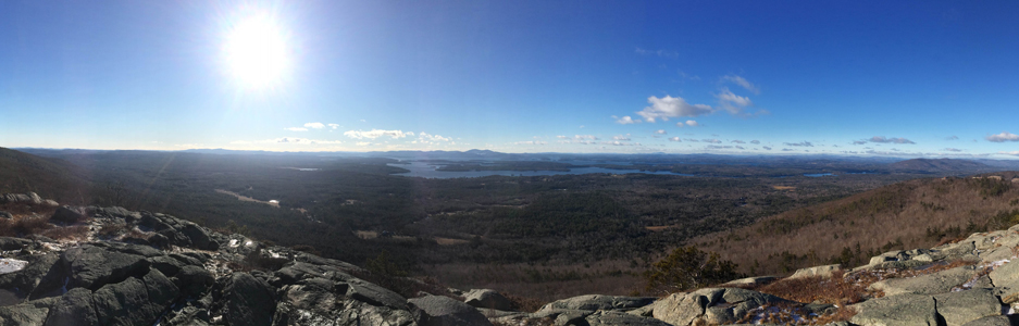
Pano from the outlook.
I think this may be rhodora about to bloom.
Peeking at Chocorua.
Boulders on the main ledge.
Sitting down for our lunch break on the ledge.
View of the western Sandwich Range from the southernmost ledge.
View toward the Lakes Region from the southernmost ledge.
I think it’s a rule that any hike that begins from a trail along Route 113A must end with a stop at The Sandwich Creamery!
I’ve hiked this mountain in the Ossipee Range a number of times in several different seasons, but I enjoy it the most in winter (or at least when there’s snow). The hiking trails are accessed via Ossipee Park Road, and the hiker parking lot is just before the gate near the horse stables on the Castle in the Clouds property. It’s about a 5.5-mile hike including the distance from the parking lot to the start of the trail. Maps are available for purchase from Lakes Region Conservation Trust, at the Castle in the Clouds gift shop, and also through several local businesses.
I was the first car in the hiker parking lot just before 8:00 AM, but I wasn’t the first person on the trail. About halfway up, there was a man coming down from the summit with his three dogs (and I think I may have crossed paths with them on a previous hike, since they seemed familiar). When I finally reached the false summit, another hiker caught up with me. I let him go ahead as I took a short break. We were both at the summit briefly, and I started my descent shortly after he left.
There was a bit more traffic on the way down. I encountered another man on his way up shortly after I left the summit (and he seemed familiar too – I’m pretty sure I’ve seen him on this trail before). Then just below the viewpoint there were two more groups of three people each. Upon reaching the upper edge of the horse field, there were three more people who appeared to be a family, most likely tourists out for a walk since I didn’t notice any backpacks or other hiking equipment.


